Atlas Mountains Map of Morocco: Regions & Travel Guide
limitlessmoroccotours.com
19 November 2026
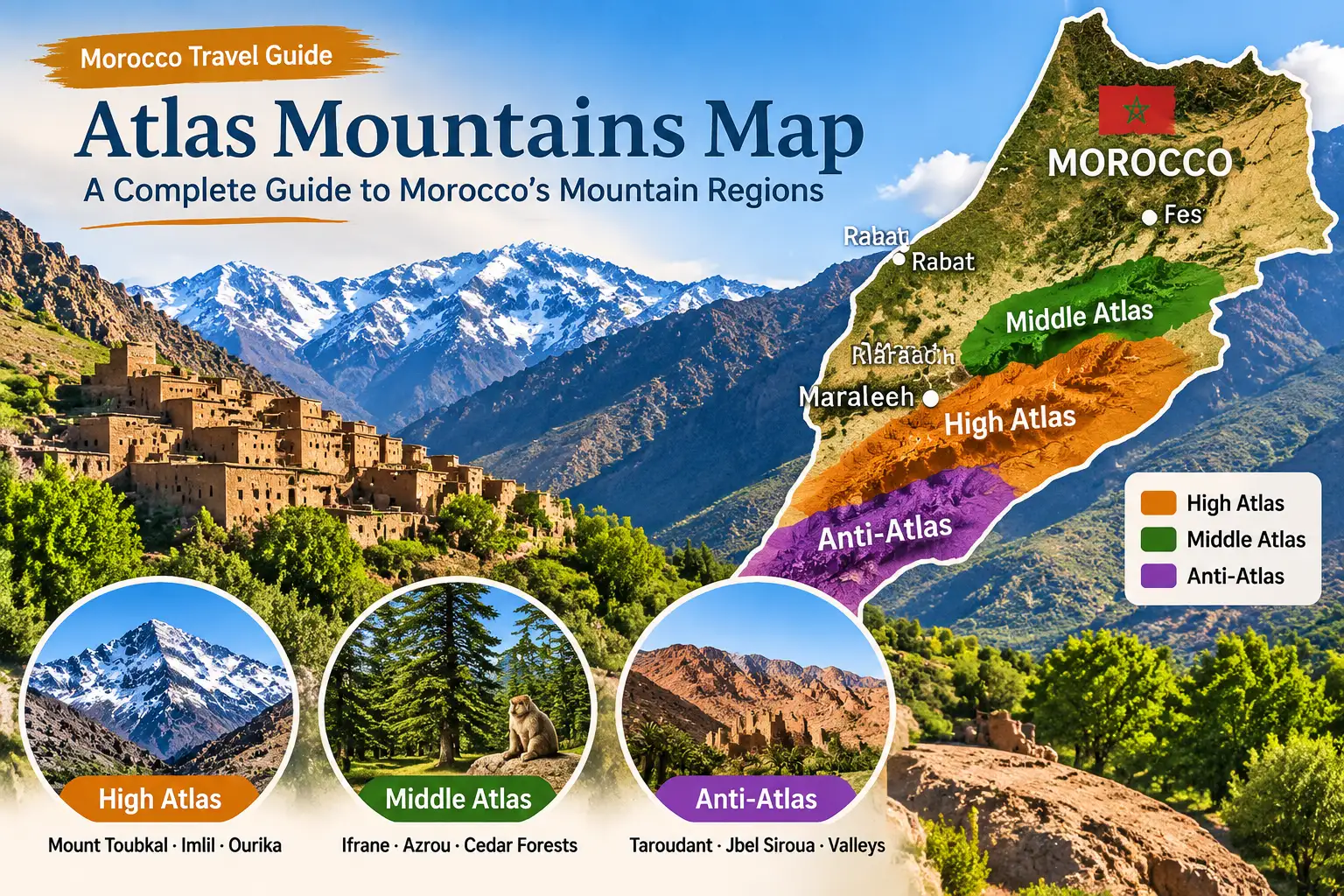
The Atlas Mountains form a major mountain system across Morocco, and a map makes it much easier to understand how its different regions fit together. In Morocco, the main ranges to know are the High Atlas, Middle Atlas and Anti-Atlas. They have different landscapes, elevations and access points, so the best area to visit depends on what you want to see.
If you are searching for an Atlas Mountains map before a trip, start by locating Marrakech, then look south toward the High Atlas. The Middle Atlas lies farther north, while the drier Anti-Atlas is in the south of the country. This guide explains the main ranges, useful places to find on a map and practical ways to plan a visit.
Open the Atlas Mountains location in Google Maps to explore the area interactively.
Where Are the Atlas Mountains in Morocco?
The Atlas Mountains run through central and southern Morocco. The High Atlas is the best-known range for visitors staying in Marrakech. The Middle Atlas covers a broad area farther north, including places such as Ifrane, Khenifra, Sefrou, Boulemane and Midelt. The Anti-Atlas lies closer to the drier landscapes of the south.
The official Moroccan National Tourism Office describes the High Atlas as extending for more than 750 kilometers. It also identifies the Middle Atlas as a range spread over about 350 kilometers. These figures help explain why the Atlas Mountains are not a single sightseeing stop: they cover a large area, and travel times depend on the exact destination.
For a reliable geographical overview, see the official Geography of Morocco guide.
How to Read an Atlas Morocco Map
A useful Atlas Morocco map should show the three mountain ranges separately rather than marking the entire area with one label. It should also show nearby cities and road corridors, because these help you understand where to start your trip.
- High Atlas: look south of Marrakech for the main visitor areas around Imlil, Toubkal National Park and Ourika Valley.
- Middle Atlas: look farther north for Ifrane, Azrou and other towns in the forested mountain region.
- Anti-Atlas: look in the south, where the landscape becomes drier and Jbel Siroua is a notable summit.
When comparing a map of Morocco’s Atlas Mountains, check the scale and labels. A country-level map is useful for understanding the ranges, but a local map is better for planning a drive, hike or village visit.
The Three Main Atlas Mountain Ranges
1. High Atlas Mountains
The High Atlas is the highest mountain range in Morocco and is often called the country’s rooftop. It contains Mount Toubkal, which rises to 4,167 meters and is the highest peak in North Africa. The official tourism office gives the range a length of more than 750 kilometers.
For visitors based in Marrakech, the High Atlas is usually the most practical mountain region to explore. Imlil is a well-known starting point for mountain walks and treks toward Toubkal. Ourika Valley and Oukaïmeden are other places to consider, depending on the season and the type of outing you want.
Toubkal National Park sits between the N’Fiss and Ourika valleys. The Moroccan tourism office describes it as a protected area a few dozen miles from Marrakech. The climb to Jbel Toubkal is a serious mountain activity; the official tourism guide describes the ascent as a two-day effort. Check current conditions and use a qualified local guide before attempting a high-altitude trek.
For official visitor information about the mountains around Marrakech, see Nature in Marrakech.
2. Middle Atlas Mountains
The Middle Atlas lies north of the High Atlas and is known for a different type of scenery. The official Moroccan tourism office describes lakes, forests of holm oak and cork oak, and volcanic plateaus across this region. It gives the range a length of about 350 kilometers.
The official geographical overview names Ifrane, Khenifra, Sefrou, Boulemane, Midelt, El Hajeb, Taza and Beni Mellal among the areas covered by the Middle Atlas. Ifrane and Azrou are useful names to look for when planning a visit to the northern mountain region.
For destination information, explore the official Ifrane travel guide.
3. Anti-Atlas Mountains
The Anti-Atlas is the drier of the three ranges described here. Its landscapes sit closer to the Sahara, so the scenery is different from the greener valleys and forests found in parts of the High and Middle Atlas.
Jbel Siroua is a notable summit in the Anti-Atlas. The Moroccan tourism office identifies it as the range’s highest peak at about 3,300 meters. If you are interested in this region, plan around the specific town, road and walking route you intend to visit rather than treating the whole Anti-Atlas as one destination.
High Atlas vs. Middle Atlas vs. Anti-Atlas
Range | Map location | Geographical features | Useful places to research |
High Atlas | Central and southern Morocco; south of Marrakech | Highest peaks; Mount Toubkal; valleys and protected mountain areas | Imlil, Toubkal National Park, Ourika Valley, Oukaïmeden |
Middle Atlas | North-central Morocco | Lakes, oak forests and volcanic plateaus; about 350 km long | Ifrane, Khenifra, Sefrou, Boulemane, Midelt, Azrou |
Anti-Atlas | Southern Morocco, nearer the Saharan region | Drier mountain landscapes; Jbel Siroua about 3,300 m | Jbel Siroua and nearby southern mountain areas |
Important Places to Find on an Atlas Mountains Map
Mount Toubkal and Toubkal National Park
Mount Toubkal is the key landmark of the High Atlas. At 4,167 meters, it is the highest peak in North Africa. Toubkal National Park protects a large mountain area between the N’Fiss and Ourika valleys. It is a destination for prepared hikers, not simply a roadside viewpoint.
Imlil
Imlil is a mountain village in the High Atlas and a common base for visitors heading toward the Toubkal area. It can also suit travelers who want a shorter walk, mountain views or a village visit without attempting the summit.
Ourika Valley
Ourika Valley is one of the mountain areas promoted by the official tourism office for visitors around Marrakech. It is a practical option for a day trip, but the route and stops should be chosen according to road conditions, available time and the season.
Oukaïmeden
Oukaïmeden is a high-altitude destination in the High Atlas. The official tourism office mentions its rocky sites and walking paths, as well as its historical rock-art interest. Conditions vary through the year, so check locally before traveling.
Ifrane and the Middle Atlas
Ifrane is a useful reference point for the Middle Atlas. The region is known for forests, lakes and cooler mountain settings. It can fit into a wider itinerary that travels through central Morocco, but it is not a quick side trip from Marrakech.
How Far Are the Atlas Mountains from Marrakech?
Marrakech is a convenient gateway to parts of the High Atlas. The official Moroccan tourism office says Toubkal National Park is a few dozen miles from the city. The exact distance and drive time depend on the destination: Imlil, Ourika Valley, Oukaïmeden and other mountain areas follow different routes.
For a short visit, choose one nearby area and allow enough time for the drive and stops. For a longer journey, you can cross the High Atlas toward Ouarzazate and continue through southern Morocco. Do not rely on a single distance for the entire mountain range; check the exact start and end points on a current map before departure.
Check the Atlas Mountains route options in Google Maps
Best Time to Visit the Atlas Mountains
There is no single best month for every part of the Atlas Mountains. Conditions change with elevation and location. A sunny day in Marrakech does not guarantee the same weather in a high mountain village or on a trekking route.
- Spring: often a good time to research valley walks and lower-elevation sightseeing. Check rainfall, trail conditions and local forecasts.
- Summer: lower valleys can be hot, while higher areas may be cooler. Start walks early, carry water and avoid underestimating the sun.
- Autumn: can be suitable for scenic drives and walking, but conditions still vary by altitude.
- Winter: higher areas can be cold or snowy. Check road access, snow and trekking conditions before setting out.
For general seasonal planning across the country, consult Visit Morocco’s climate and seasons information.
Ways to Explore the Atlas Mountains
Day trip from Marrakech
A day trip can work for a nearby destination such as Ourika Valley or Imlil. Choose one main area instead of trying to cover several distant places in a single day.
Private guided tour
A private tour can make transport and route planning easier, especially if you want to combine the High Atlas with kasbahs, valleys or the Sahara. For example, the [10-Day Morocco Tour from Marrakech](https://limitlessmoroccotours.com/10-day-morocco-tour-from-marrakech/) crosses the High Atlas on its way toward Aït Ben Haddou and the southern routes.
Longer Morocco itinerary
If you have more time, a longer route can include both the High Atlas and Middle Atlas. The [12-Day Morocco Tour from Marrakech](https://limitlessmoroccotours.com/12-day-morocco-tour-from-marrakech/) is one existing itinerary to review when comparing a wider journey through the country.
Hiking and trekking
Choose a route that matches your fitness, experience and available time. Short village walks and a high-altitude summit trek are very different activities. For Toubkal, confirm the current requirements, weather and guide arrangements before departure.
Practical Tips Before You Go
- Check the forecast for the exact mountain destination, not only Marrakech.
- Wear shoes suitable for uneven paths and bring layers for changing temperatures.
- Carry drinking water, sun protection and any personal medication you need.
- Ask about road conditions and travel times before setting out.
- For longer hikes, use a qualified local guide and confirm the route difficulty.
- Respect village customs, private property and local requests before taking photographs.
- Keep some flexibility in your schedule in case weather or road conditions change.
Frequently Asked Questions About Atlas Mountains Map
They extend through central and southern Morocco. The main Moroccan ranges discussed in this guide are the High Atlas, Middle Atlas and Anti-Atlas.
The High Atlas is visible from Marrakech on clear days. The city is also a practical starting point for trips into nearby mountain areas.
It depends on the destination. The official tourism office describes Toubkal National Park as a few dozen miles from Marrakech; check the exact route to Imlil, Ourika Valley or another destination.
Mount Toubkal is the highest mountain in Morocco and North Africa, at 4,167 meters.
They are the High Atlas, Middle Atlas and Anti-Atlas. Each has different geography and visitor access.
Yes. Some destinations near Marrakech can be visited on a day trip. A summit trek or a journey deeper into the ranges requires more time.
It depends on the area and activity. Check local forecasts and trail or road conditions because weather changes with elevation.
For visitors staying in Marrakech, the High Atlas is often the simplest starting point because several well-known mountain destinations are within reach of the city.
Plan Your Morocco Trip
The Atlas Mountains cover several distinct regions, so the right route depends on your starting city, travel dates and interests. If you want to combine mountain scenery with Morocco’s historic towns or the Sahara, explore the private itineraries from Limitless Morocco Tours and ask the team which route fits your plans.
- 4-day Casablanca to Marrakech desert tour
- 5-day Morocco tour from Casablanca
- 7-day Sahara desert tour from Casablanca
- 8-day imperial cities tour from Casablanca
- 10-day Morocco tour from Casablanca
- 10-day Imperial cities Tours from Casablanca
- 12-day grand Morocco adventure tour
- 14-day Morocco tour from Casablanca
- 3 Days Tour Marrakech To Merzouga Desert
- 3 Day Marrakech to Fes Desert Tour via Merzouga & Erg Chebbi
- 4 Day Sahara Desert Tour from Marrakech
- 4 Day Marrakech to Fes Desert Tour with Camel Trek & Sahara Experience
- 5-day Marrakech to Fes desert tour
- 6 day Morocco desert tour from Marrakech
- 7-day imperial cities tour Marrakech